Rain chances increase as a meandering cold front tries to push deeper south. The NWS is giving us a fifty percent chance for the evening – the biggest chance of rain we have had in over two weeks. It has been a dry start to the Fall. A slight cool down will accompany the front with highs in the upper eighties most days and the lows hovering around sixty degrees. It will take a much stronger, more robust cold front to bring Fall to us this far south. This front just isn’t going to do that.
Current Conditions…
| ||||||||||||||||||
Igor Set to Become a Hurricane…
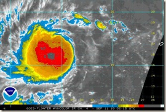
IGOR: Tropical Storm Igor is 2,200 miles east of St. Martin tonight, moving west at 20 mph. Top winds are 50 mph.
The storm is gradually looking more impressive on satellite imagery this evening, but it is still undergoing some shear.
The storm will slowly strengthen, becoming a hurricane during the next 24 hours. As it does, it will also slow its forward progress.
By Wednesday, it will be turning more to the northwest and will pass about 500 miles northeast of St. Martin as a major hurricane. By next weekend, Igor will be an even more powerful storm east of the Bahamas, moving northwest slowly. All indications are that the hurricane will turn north and then northeast, to the east of the East Coast.
JULIA: Is a strong disturbance over the eastern Caribbean Sea. Investigations have shown a strong low level circulation, so it is only a matter of time until it becomes a tropical depression and tropical storm over the next couple of days.
Some of the models like the GFDL carry it toward the Yucatan Peninsula as a major hurricane by Wednesday. Could it get into the Gulf? Only time will tell. Reassuringly, the GFS was reliable in its forecasts for the remnant low for Gaston, and it does not forecast this disturbance to amount to anything.


0 Comments:
Post a Comment